Hike 65 – Barlow Pass to the Pacific Crest Trail

About a year ago my new doctor changed up some of my routines and I stopped getting migraines. I still get headaches, but they don’t knock me down like they used to. My regularly scheduled acupuncture does a good job of keeping my headaches manageable. That was until this last Saturday. On Saturday I was sitting in a computer lab at Reynolds High School getting very important Oregon Battle of the Books moderator training. I could NOT see out of right eye. There was just a checkerboard of weirdness over there. Sometimes when I get occipital migraines, the actual migraine never manifests. However, that is like 2% of the time. I still had hours of OBOB moderating to do, so I was more than a little worried as I covered up my eye and tried to see the powerpoint presentation that described my very stressful role for the next few hours.

I talked to my friend Lisa, who was brilliantly running OBOB, and she said I could leave after the first round of play. Whew! Crisis averted. About halfway through the first battle (there are three), the pain kicked in. I had some of my favorite people as my assistants, so we made it through.

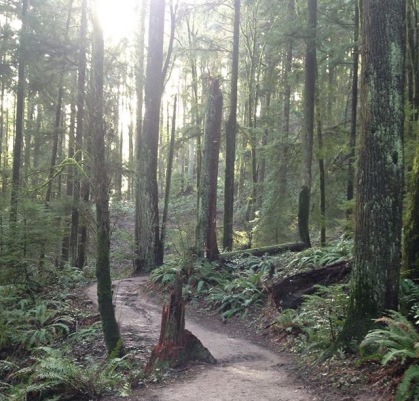
I was relieved when I left the school, but I probably shouldn’t have driven. It is very hard to see when your head hurts that much. I drove to my sister’s house, because we had planned to hike anyway, and like I’ve mentioned before, it’s the only cure I know for migraines. She fed me and made sure I was comfortable and then we headed up to Barlow. We considered trying a new spot, but we had never actually hiked the real trail, so we just stuck with what we knew.

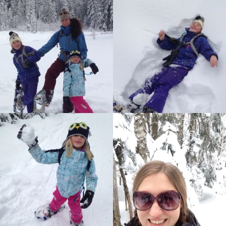
The parking lot was pretty empty, since rain was in the forecast. We walked over to the trail and put our snowshoes on. A couple was coming up the hill. The snow was icy and super packed. The beginning of the trail has a lot of downhill and I didn’t have my poles set correctly, so it was slow going and dangerous.

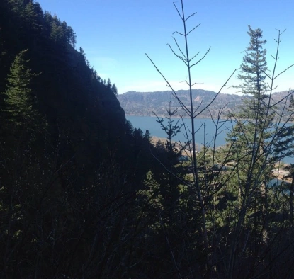
We hiked for several hours. I have no idea where we went, and I didn’t care because my migraine was gone and I was even hiking in the bright light with no sunglasses. Fresh air and sweat, it cures what ails ya! Again, in the snow it’s hard to tell. We lost the trail twice and were looking desperately for the blue diamond markings. We found them. My sense of direction is pretty rock-solid, so I wasn’t worried. We did 3 miles up, according to Jessie’s phone and then it got cloudy and dark, so we decided to head back. As soon as we turned around, it started to pour. It did not stop raining the rest of the hike.

On the way down we were quick, until we hit the trail turn-off where we had to go uphill. We slowed to a crawl. We had gone too far and had no power left. We both fell. My sister fell on her snowshoes and then accidentally sledded down a small hill we were trying to negotiate. It was hilarious. My fall was tripping and then stepping on my own shoes. It took me a really long time to get up and it required my sister’s help. Injuries make falling really scary for me.

But eventually we made it back to the trailhead, Sid, our trusty steed, calling to us from a distance. We were so tired. It was a glorious day!

Hike 64 – Barlow Pass to Woman’s Pioneer Grave

The thing about snowshoeing that is really a lot a different than hiking is I have no idea where we hiked or how far. The signs are totally buried and really, as long as you’re in the beautiful snowy scenery who cares, right?

When my sister and I parked at the Barlow Pass Sno Park, we had no idea where we should go. Jerbear Wedell told us that we should snowshoe at Barlow and he’s never given us bad advice before, so we listened. There was an obvious trail that most people were taking and then there was what looked like a road at the end of the parking lot. Nobody was heading that way, so it seemed like the best option.

It was obvious that it is normally a road, but with several feet of snow on it, it was a lovely snowshoe trail. We didn’t really know where we were going until we got there. It was the road to the Pioneer Woman’s Grave. The snow was a bit sloppy because it had been raining, so we sank in pretty deep. We did a lot of laughing at our numerous missteps and ridiculous near falls.

According to my sister’s phone, with side trips, we descended a little over 3 miles. It was downhill the whole way. That frightened us a little because we’re notoriously awful at ending on an uphill. As we neared the bottom of the hill, we found a great side trail and hiked in a ways to eat a snack. We settled down on the snow pack and chowed down. We were super-duper hungry. Our timing was a bit off for meals.

When we finished we hiked back out to the road and headed back up. I was definitely worried about my endurance, but it turned out to be totally fine. Slow and steady we made our way back up the hill and then, gloriously, it started snowing big giant flakes on top of us. I did not drive a snow-ready car to the parking lot, so I was a little concerned, but it was still pretty warm. I hoped it wasn’t sticking. We hiked in the beautiful snow uphill for the last hour.

When we got to the parking lot our trusty steed was patiently waiting on totally clear pavement. We needed nourishment.

We stopped for warm drinks and greasy food on the way back to town. Snowshoeing is an incredible work out and it’s so peaceful. I adore it.


Hike 64 – Lower Maclaey Park to Pittock Mansion

Pittock

It was Saturday and I needed to get out of the house. I had acupuncture at 2, so I woke up early, ate delicious gluten free cereal from Trader Joe’s, and headed to Forest Park. As I’ve mentioned before, I have spent a ridiculous amount of time in Lower Maclaey Park in another life. I even went to a midnight acoustic death metal show there once. It was so crazy, candles, an unhealthy amount of black clothing and hair, and many many broken guitar strings. It was kind of fabulous.

Anyway, when my sister and I did this hike before it was eighteen degrees outside. While we enjoyed ourselves, it was difficult to really take in the scenery. This time was much much better. The only drawback was the crowds. They mostly stay within spitting distance of the entrances, but they are numerous, so it’s tricky.

Right as I exited the paved portion of the trail, at the bottom, and hit dirt, there was a hotbelly pig (cutie-pants small kiddos once called Remi that). She was so cute and I couldn’t believe she took hikes. Her owner was very nice and wanted to know all about Remington. Apparently, this sweet little girl pig was very even tempered and ran around with her dog friends so much she was even a little under weight. I’m still convinced that I should have bought Remington a girl pig to boss him. It’s too late now.

Once I got away from the bustle of the entrance the hike was gorgeous. I crossed over to Upper Maclaey and started the crazy switchback filled ascent. It was very hard for me because I had a cold; mouth-breathing was abound. I’m tenacious though and kept my “one foot in front of the other” motto in my mind. When I started to get towards the top a TON of people were descending. One group was listening to terrible techno music in the middle of the forest. I couldn’t even hear the birds when they came by. I was super annoyed, but I let it go. Then another group laughed at me because I was so out of breath. Whatever.

I finally got to Pittock and the view did not disappoint. It never does. I took a swig of water and headed back down. A little thing called Karma kicked those laughers and revelers in the butt as they passed me going the other direction. Needless to say, they too struggled with the climb: Haha!

I got back to the car refreshed and with just enough time to head home, eat lunch, and walk to acupuncture.

For information about Maclaey Park to Pittock Mansion here.

Hike 63-Glacier View to Mt. Hood Brewing

IMG_7370

I finally tried Snowshoeing! And, it was glorious. Now I’m addicted. The extraordinarily spontaneous Talla Hamalainen posted some pictures of snowshoeing on a Saturday. On Sunday morning I texted her, “Looks like fun. I’m jealous.” She texted right back, “Wanna go play in the snow today.” I immediately responded, “Yes. Are we skiing or snowshoeing?” She wasn’t sure so I packed both and headed straight to the Hamalainen/Kanable Compound.

After finding enough snowshoe rentals for the entire Hamalainen Crew, we headed to Glacier View Sno Park. I have been going to Skibowl my entire life and I never even noticed there was a parking lot across the street. I guess it’s that I’m so excited to go skiing I’m not very observant at that point. Plus, super bonus, I got to ride in Talla’s brand new Exploder. It’s super nice, and I’m more than a little envious.

The parking lot was snowy, so we put our snowshoes on right as we got out of the car. I had never even unzipped the bag they came in, so I had to figure mine out a bit. They were super easy. If you’re going to buy them you should get the Costco ones. They are made for simplicity. I adore them.

We walked to the trailhead and started our snowshoe hike. The girls were super stoked when we first started. They were running around like crazy people and jumping into and out of the snow. We walked right to Enid Lake, which is awesome in the snow. It’s not a stupid anti-climatic swamp at all. Then we continued on the Glacier View Trail. It was cold and snowy and just downright gorgeous. Snowshoeing is super different than hiking. It is way more cardio, first of all. It’s also much much easier for me to injure my back. I am so clumsy and I step on my own snowshoes a lot. It also doesn’t work quite the way you would expect it to. You sink quite a bit despite the snowshoes. You also slide around and can roll a fresh ankle pretty easily. It works totally different muscles too, muscles I’ve never felt before.

On this first trip, I was hiking with a 6 year old, which was a perfect way to get it all figured out, a nice steady pace. We did a total of 3 miles and it took us a very very long time. We hiked Glacier View until it hit Annie’s junction trail and then took that to Wally’s trail which took us to Government Camp. We wore our snowshoes all the way to the door of Mt. Hood Brewing where we enjoyed warm drinks and soup. Then we headed back.

The trek back was shorter; we took a different route. Unfortunately, it was a little too much for for the kiddo. Oh, there were tears and yelling and snowshoes thrown, but Talla handled it like a champ.  I adore my friends’ kids and I’ve seen every single one of them break down at some point. It doesn’t make me love them any less. They are my sweet, adventurous girls. There was a lot of laughter and I found a new passion. Thanks for that Hamalainen Crew!


Hike 62 – Old Salmon River Trail (Again)

This is the other trail that has Aunt Patti’s ashes on it, and is just one of my favorite chill hikes. It’s almost flat, but a good 5 miles with beautiful features. Also, you can stop and rest at any point putting your tired feet in the cold, clear water.

As we sat on the shore, we created an entire story around a small fish that was hanging out by our feet. We gave him a name, which neither of us can remember. We talked about his family and how he liked us so much he would follow us up river as we hiked. While we were sitting there this other bigger fish was stalking him from the shadows. I was like, “Look that fish is totally stalking him.” Right as I sad that he made his move. Our fish friend was no more and the predator moved back into the shadows to wait for his next meal.

The picture of my sister in the sun on the trail is one of my favorite hiking pictures ever. It completely sums up what hiking is to me, just a girl and nature.

One thing we noticed about the hike this time around was how ridiculously low the water was. A year previously we had to take a detour to the road to get around some raging side creeks. Those same creek beds were completely dry this time around. While that was convenient for our hike, it would just be the first of many times in the summer of 2015 that our plans were changed by a lack of water. The water situation was scary. I hope that 2016’s rain is plentiful and makes up for it.

For information about the Old Salmon River trail click here.

Hike 61 – Wahkeena to Devil’s Rest to Angel’s Rest


FullSizeRender (3)

Honestly, this was not a very good hike, but it was because of me, not because the hike was bad in any way. I love hiking Wahkeena, but I hate the crowd at Multnomah Falls. They turn me into a very cranky person. I looked for alternate paths to take and discovered I could go up to Devil’s Rest and circle back around. Problem solved.

I’m very familiar with the Wahkeena portion of the hike, but as I’ve mentioned before, the signs in the gorge are terrible and probably responsible for so many people getting lost on hikes up there. I had my directions and knew where I was supposed to go… in theory. On the way up I was really scared about hurting my back, so I went really slow. Uphill laziness causes me to hunch forward slightly and that is the absolutely worst position for my back. I have to stop, stretch, and really focus on posture. Getting to the top was triumphant. It’s a 7.5 miles hike with 2,550 feet in elevation. It was definitely a challenge for someone who hadn’t been hiking. I took cherries from the farmer’s market with me and that turned out to be the perfect hiking snack. I enjoyed being up there for longer than I usually rest on hikes.

It’s when I passed Devil’s rest that things went awry. There was a turn off, somewhere, but I certainly never saw it. I ended up at Angel’s Rest, which was lovely. However, it was swarmed with idiots, as it usually is, and they were blasting music and singing, and doing all sorts of things that are just not allowed on hikes. I was so annoyed. I can’t even explain the expression that must have been plastered across my non-poker face.

After soaking in the view and trying to ignore the neanderthals around me, I convinced myself that the cut-off was on the way down. I started to descend at Angel’s Rest. As it turns out, the cut-off trail was way back in the distance. I had totally missed it. As I passed hundreds of people on my way down the Angel’s Rest switchbacks, I vowed, much like Multnomah Falls, to never hike Angel’s Rest again. It is ruined. People ruin everything.

Eventually I emerged from the forest at the Angel’s Rest trailhead. I pulled out my phone to check the distance to my car. The Wahkeena trailhead was just over three miles away, on the road with no shoulder at all. I took a deep breath, put in my headphones, which I never wear while hiking, and braved what would surely be my death.

My phone said it was a 40 minute walk. I did it much faster. I got honked at, four times. I jumped off the road once to avoid certain death. I did some precarious other side of the barriers cliff-hanging, and eventually I made it back to Wahkeena.

There were hundreds of cars parked there, for miles. However, mine had a parking ticket, $80, for my car being slightly on the road. I took pictures. I tried to fight it. They didn’t even respond. While I was taking the pictures, the car right behind mine, which didn’t have a ticket but actually was way out in the road, got hit. It was a hit and run. They sped away laughing. It was nuts.

The beginning of the hike was lovely and challenging. The end was ruined by idiots, including me.

For information about Wahkeena Falls to Devil’s Rest click here.

Hike 60 – Maple-Wildwood Loop Hike

FullSizeRender (4)
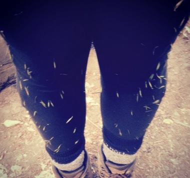
I know it’s super weird to only have a picture of my legs, but we just didn’t take any pictures until the end of this hike for some reason. It was a really pretty day and we enjoyed the hike immensely. We enjoyed it so much that we were immersed in the hike and not in documenting it.

My sister and I set a goal a long time ago to hike all of the trails in Forest Park. We still haven’t come anywhere close to reaching that goal. The Maple-Wildwood loop is 8.4 miles with only 1080 feet in elevation change. It has a lot of beautiful things to see and we only retraced our steps from another hike we had done (Leif Erikson) for about 50 feet.

The hike starts at the Lower Salzman trailhead. There were a lot of cars parked there, but we were able to parallel cram our trusty steed and hit the trail. The loop has a combination of different junctions and trail switching, so that you end up seeing a great deal of the park. It hits Salzman, Leif Erickson, Wildwood, Maple, and others. It’s a nice loop that is not too difficult to follow.

There were many features (bridges) in various locations, a ton of plant-life, a cool snake, some birds, one or two crazy mountain bikers, and gallons and gallons of fresh air. We did go the wrong direction once, not because there was a missing sign or anything, but because I am terrible at reading directions sometimes. We figured it out and got back on track.

We hiked fast because we were hungry and we wanted to go get lunch. You gotta have priorities.

For information about the Maple-Wildwood Loop Hike click here.

Hike 59 – Wahclella Falls

Like I mentioned in the previous post, I did not hike for four months. Beyond being slightly traumatized, I re-injured my back and my knee. I tore my meniscus in 2003 and I herniated a disc in my back in 2013. I had surgery on  both at the time. Both injuries had returned. I went to the gym and worked with a trainer. I went to physical therapy every other week. I started getting acupuncture regularly. At present, I still have a herniated disc. I still have a torn meniscus, and I have added a torn meniscus in my other knee. Acupuncture, activity, and collagen in my coffee keep me comfortable. I don’t even take Advil. My sister’s theory is that I’m just super resistant to pain. Maybe I inherited that from my mom. She’s one crazy tough chick.

As summer break set in, I was spending a lot of time at the river. I swam in the Clackamas and the Salmon over 50 times in 2015. Cold water and no-impact are miracle-workers for injuries. However, when the wonder-mom, Becky Curry, called to see if I wanted to hike Wahclella with the Curry Crew, I was in. I figured my first hike should be slow and cute. It did not disappoint.

We packed lunches to eat at the falls and we headed out. Wahclella is the perfect hike for beginners or kiddos. It is one mile each way, with negligible elevation gain, and a lot of pay off. Plus, the Curry Crew had hiked it before, so I was basically with experts.

It was slow going, but it was a beautiful day. We stopped frequently to enjoy nature and for the girls to claim this rock or this tangle of trees “my house.” We spent a lot of time looking at these houses and then upgrading around the next bend. When we reached the falls it was incredible. The sun was shining and sparkling in rainbows as the mist hit the air. There were a lot of people there, but not enough to make it crowded.

While we ate our food and chatted, crazy people jumped into the water and swam around. It was not warm enough for that. I contemplated it, because I’m a bit of a dare devil, truth be told, especially about water, but I had no swim suit and a slow walk back in wet pants sounded like no fun at all. Instead, I took off my boots and socks and soaked my feet with the giggling girls. It was heavenly.

Eventually we had had enough waterfall time and we headed back. As we walked on one of the steeper portions of the trail a snake came slithering down right in front of us. Small “screams” and back-stepping toward the cliff were the result, but we all survived.

It was an incredible day and I can’t wait to do it again.

For information about Wahclella Falls click here.

Hike 58 – Eagle Creek to Camp Smokey


It has taken me a ridiculous amount of time to write about this hike, for many many reasons. I did this hike almost a year ago, last spring break. It broke my spirit a little bit, but I’m over it now and that’s why it is time to write about it.

As I mentioned in many earlier blog posts, the goal for last summer was hiking the JMT with the one and only Lacey Wroblewski (and her mama). After Spring Break, those plans changed. The experience just really sullied everything hiking for me. It’s okay though, my sister and I intend to keep hiking and do a PCT adventure next summer.

Eagle Creek is beautiful. I have hiked it many times, but never with the intention to camp or multi-day hike, so this was a new adventure. I had my brand-new awesome tent and light-weight sleeping bag. The new fantastic backpack that Sharock Bruce Hannah, Esq bought for me held lots of supplies borrowed from the extraordinary Jerbear Wedell. I was ready. It was a bit rainy, but when isn’t it in Oregon, right?

The first part of Eagle Creek I have hiked numerous times. It is always amazing and beautiful and you better believe it was packed for Spring Break. It is also sentimental because my sister and I deposited our Aunt Patti’s ashes in Punchbowl Falls. Lacey had planned the hike and I knew eventually we were taking a cut-off trail that I had never hiked before and that it was steep. Oh my goodness, understatement of the century.

My sister and I have hiked lots of steep stuff. This definitely rivaled that. It was not the steepest thing I have ever hiked, but it was steepest for the longest. It was hard, but the views were incredible and it was beyond worth it. We crossed several creeks, we rested and ate Snickers bars, and we went over and under so many downed trees it was almost a joke as we came to another one across the path. With my back injury, it is very hard for me to go under a downed tree. It made for some interesting acrobatics to be sure.

Eventually we reached Camp Smokey. It was triumphant. Lacey filtered gallons of fresh water for us. We cooked dinner (freeze-dried deliciousness), we drank whiskey, we sent up our tents, and we turned in early.

For the first few hours or so I slept soundly, then the nightmare began. I cannot explain what happened because I don’t really know, but if I had to guess I would say the worst case of food poisoning ever. From about 10 pm to when I finally crawled out of my tent the next morning, I threw up over 20 times. I ended up digging a hole right next to my tent so I could just lean out and barf when I needed to, every half hour or so. I don’t recall ever barfing so much in one night before, except maybe when I had mono in high school.

When I did get out of my tent to go to the bathroom. I walked about 30 feet from camp and had trouble getting back. Finishing the hike, up to Wahtum Lake and around to Tunnel Falls was not an option for me. I had to go back. Unfortunately, I did not have a map. Because I had no calories in my body and was running on no fuel, my brain could not function. The only way to get back was down the crazy steep Eagle-Benson trail we had hiked up the day before.

Lacey and her mom continued on the hike. I sat down and cried for a long, long time. Then I drank some water, ate a bite of peanut butter and tried to hike back. The first part was uphill, barely, it took me FOREVER. After about 20 minutes I barfed up all the water and the peanut butter. I wiped my mouth and drank more water. Then I continued on.

You don’t need all the gory details, but it took me nine hours to get down. I fell a lot. I barfed a lot. I cried a lot. I screamed a lot. When I hit the Eagle Creek trail and saw other people, I sat down in the middle of the trail and cried. They were tears of joy. I was not going to die alone on a mountain. It was a good moment. I had been alone for about 5 hours at that point. I was so out of it I had convinced myself I would never see another human being again. Several strangers helped me, carrying my pack varying distances. I continued drinking water and barfing it back up the entire time. I sat down on the trail when I could go no further, which was frequently. I got a lot of help.

When I eventually got to my car, I threw my backpack on the ground, crumbled into a pile on the rainy ground and sobbed. A guy walked up and said, “Are you okay?” I said, “Yes, now I am. Thanks for asking.”

I got up. I unlocked the car. I called my mom to tell her she didn’t need to feed Remington because I was coming home a day early. I drove to a gas station and bought Gatorade. I drank it slowly and then had to pull over on the side of Highway 84 to barf it all up. I barfed for three days. I didn’t hike for four months after that.

So, that was my Spring Break hike to Camp Smokey. I’m over it. Hiking is still amazing. The adventure continues.

For information about Eagle Creek to Camp Smokey click here.

Hike 57 – Wahkeena-Multnomah Loop

Wahkeena Pano

Last year my sister and I hiked Wahkeena Falls in the fall. It was one of our favorite hikes, by far. I can’t even begin to explain how incredibly beautiful it was. My sister really wanted to hike it again this year, but she just couldn’t fit it in around wedding planning, so I did it solo. It was still pretty darn cool.

Recently one of my friends posted a picture of her hiking view from Angel’s Rest on Instagram. It was a really pretty picture, and I liked it. The ex, who also follows her, commented “best hike in the gorge.” False. If you never go on hikes in the gorge and that’s the one that you always do, then yes, you might think it’s “the best.” But really, it is not. That is quite frankly naivete. Wahkeena is a far superior hike to Angel’s Rest, as is Hamilton Mountain, Coyote Wall, and a couple others. Angel’s Rest is pretty in a few spots (on the scree field and when you get to the top) but it’s mostly a view-less hell of switchbacks. The other hikes listed here are far superior. I dislike when “know-nothing-know-it-alls” speak as experts from a perspective of ignorance. I am an expert now. I know. Thanks 52 hikes in 52 weeks.

The Wahkeena Loop does have one problem, the Multnomah Falls part sucks big time (Like Tommy Tomasino – that’s a The Sixth Sense reference). The Wahkeena side is incredible. It’s mostly uphill, but it stays next to a raging creek/river and has numerous waterfalls and bridges. In the fall, coupled with the leaves, it’s breathtaking. The entire hike is 4.9 miles with 1600 feet of elevation change, but it’s entirely uphill one way and entirely downhill the other. It’s nice to have that triumphant moment when you’re half done and have reached the top. That happens at a crazy intersection of several trails that is poorly signed. Luckily, I remembered the correct trail to take. And here’s the best thing, the most beautiful part of the hike is on the downhill side toward Multnomah Falls.

The falls above Multnomah are so much more than Multnomah itself, because you can actually get close and experience them. There are many and they are powerful and cold. Even though it was October and far too cold to swim, I found a swimming hole and desperately wanted to jump in. The water was so clear and I just have this thing about water. I put my feet in, but stopped there because I still had a long way to go. In retrospect, I should have jumped in. I wish I would have.

Like last time I hiked the loop, when I reached the paved portion of the Multnomah Falls trail it was just a huge disappointment. It was crowded with people who don’t like hiking and have no trail etiquette. I was beyond frustrated. Next time I do this hike I’m going to hike to the top of Multnomah and then go back over to Wahkeena. I’ll just avoid the insanity all together. When I got down to the return trail, it was closed. I had to walk back on the road and the drivers were really really rude. It just cemented my plan to never go that way again.

I started the day with a migraine. That’s why I went hiking. Sometimes I have migraines for three or four days straight, especially in this last year. Nothing makes them go away. Nothing even dulls them. But, every single time I hike with a migraine, by the time the hike is done, it is gone. As I was descending Multnomah, my head still hurt. I thought the magic was gone, but when I got to the car I was fine. Hiking cures what ails you, physically and emotionally. I’m so fortunate to know that.

For information about the Wahkeena-Multnomah Loop click here.